|
Human
activity, including an ever-increasing population and
excessive grazing by livestock, has had a severe impact
on the natural ecosystem in Rajasthan. The lack of rainfall,
poor vegetation, low soil fertility, susceptibility
to erosion, and a series of droughts have also left
their mark on this region. Yet fascinating vestiges
remain of the original topography and natural ecosystems.
While the claim is that Rajasthan's desert is entirely
man-made, is an exaggeration, the role of the human
population in accentuating aridity cannot be denied.
|
|
Sandy Arid Plains
(Marusthali)
|
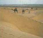
This
region, also known as 'Thar Desert', comprises sand dunes
interspersed with siltcovered valleys. It extends to about
40,000 square miles.
|
|
Semi-Arid
Plains
|
|
These
stretch from Shekhavati in the north to the Godawar plain,
north of Mount Abu in the south, with the Aravallis to the
east. Seasonal water courses, such as the Sukri -Jawai,
originating in the Aravallis, flow through it. The plains,
sparsely
|
|
covered
with trees and bushes, are studded with
rocky outcrops and sand hills called bhits.
|
Aravalli Range
|
|
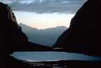
The
most distinctive and ancient mountain chain of peninsular
India, the Aravallis mark the site of one of the oldest geological
formations in the world. Heavily eroded and with exposed outcrops
of slate rock and granite, it has
|
|
summits
reaching 4950 feet above sea level. It bisects the State of
Rajasthan.
|
Eastern Plains
Sloping gradually eastward from
the Aravallis, the plateau consists of undulating,once forested
hills, especially in southern Mewar around the Bagad region of Udaipur,
where there is more rainfall.
Chambal
Valley
The middle portions of the Chambal, the
largest river and most reliable water source of Rajasthan, are
marked by heavily eroded valleys and ravines. The region is a
low plateau,cut by the Vindhya range, and covered with shallow
soil, exposed rock, and coarse grasses in the upper reaches.
Stabilised Sand
Dunes
Some sand dunes have been stabilized by
Calligonum polygonoides shrubs and clumps of Panicum turgidum.
Longitudinal Sand
Dunes
The dunes, often parallel, usually
run in a northeast to southwest direction, corresponding to the
prevailing monsoon and winter wind directions.
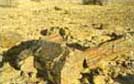
Wood Fossils
During the Jurassic age some
180 million years ago, the western region of Rajasthan was covered
by forest. Now much of the region is desert. The forest was fossilized
in geological times and buried by soil and sand in recent times.
Wind and water erosion has exposed colorful wood fossils of large
coniferous trees.
These fossils are scattered over a large area 11 miles south of
Jaisalmer.
Shell Fossils
Shell fossils are the remnants
of the marine life which exited in the desert region of Jaisalmer
some 2000 million years ago.
Mount Abu
|
|
The
Abu massif in the southwestern corner of Rajasthan rises from
the plains, a rocky outcrop separated from the Aravalli range,
forming a distinctive microcosm of its own. Its highest point,
Gurushikhar peak, reaches 5693 feet above sea level.
|
|